


An urban heat island occurs when a city experiences much warmer temperatures than nearby rural areas.
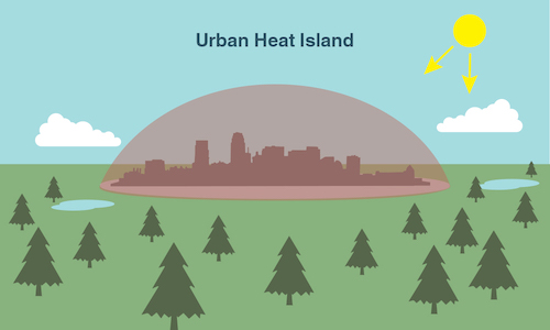
An illustration of an urban heat island. Image credit: NASA/JPL-Caltech
Why does this happen?
An urban area is a city. A rural area is out in the country. The sun’s heat and light reach the city and the country in the same way. The difference in temperature between urban and less-developed rural areas has to do with how well the surfaces in each environment absorb and hold heat.
If you travel to a rural area, you’ll probably find that most of the region is covered with plants. Grass, trees and farmland covered with crops, as far as the eye can see.
Plants take up water from the ground through their roots. Then, they store the water in their stems and leaves. The water eventually travels to small holes on the underside of leaves. There, the liquid water turns into water vapor and is released into the air. This process is called transpiration. It acts as nature’s air conditioner.
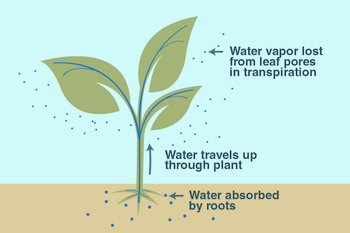
An illustration of the process of transpiration. Image credit: NASA/JPL-Caltech
See it for yourself!
You can feel cooling transpiration at work on a hot summer day. On a sunny day, go outside and find a sidewalk that is right next to a patch of grass. Feel both surfaces. The grass should feel cooler on your skin than the pavement—and that’s mostly due to transpiration!
When you visit a big city, you won’t see many plants. Instead, you’ll see sidewalks, streets, parking lots and tall buildings. These structures are usually made up of materials such as cement, asphalt, brick, glass, steel and dark roofs.
What do urban building materials have in common?
First of all, materials such as asphalt, steel, and brick are often very dark colors—like black, brown and grey. A dark object absorbs all wavelengths of light energy and converts them into heat, so the object gets warm. In contrast, a white object reflects all wavelengths of light. The light is not converted into heat and the temperature of the white object does not increase noticeably. Thus, dark objects—such as building materials—absorb heat from the sun.
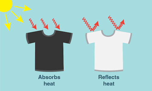
Dark surfaces--whether a black t-shirt or an asphalt street--absorb the sun's heat, while lighter colored surfaces reflect heat from the sun. Credit: NASA/JPL-Caltech
To cool down urban heat islands, some cities are ‘lightening’ streets. This is done by covering black asphalt streets, parking lots, and dark roofs with a more reflective gray coating. These changes can drop urban air temperatures dramatically, especially during the heat of summer.
Planting gardens on urban rooftops can also help to cool down the city, too! In fact, a study in Los Angeles, California, calculated that changes like these would be enough to save close to $100 million per year in energy costs!
Urban building materials are another reason that urban areas trap heat. Many modern building materials are impervious surfaces. This means that water can’t flow through surfaces like a brick or a patch of cement like it would through a plant. Without a cycle of flowing and evaporating water, these surfaces have nothing to cool them down.
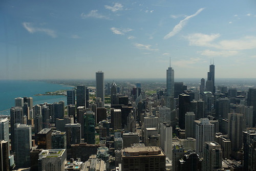
Skyscrapers in Chicago. Image credit: Flickr user GiuseppeYahoo Cortese
To help cool the heat island, builders can use materials that will allow water to flow through. These building materials—called permeable materials—promote the capture and flow of water, which cools urban regions.
What does it mean?
Urban heat islands are one of the easiest ways to see how human impact can change our planet. After all, sidewalks, parking lots and skyscrapers wouldn’t exist if humans weren’t there to build them. And although these structures are essential to city living, the heat islands they create can be dangerous for humans.
In the summer, New York City is about 7°F (4°C) hotter than its surrounding areas. That doesn’t seem like much, but these higher temperatures can cause people to become dehydrated or suffer from heat exhaustion. The hot temps also require more energy to operate fans and air conditioners. This can lead to power outages and a serious danger to public health.
But, there are things we can do to help cool the cities down. And NASA satellites can help to figure out where these cities are the hottest.

Caption: These images from the NASA/USGS satellite Landsat show the cooling effects of plants on New York City’s heat. On the left, areas of the map that are dark green have dense vegetation. Notice how these regions match up with the dark purple regions—those with the coolest temperatures—on the right. Image credit: Maps by Robert Simmon, using data from the Landsat Program.
Earth-observing satellites, such as Landsat and Suomi-NPP, can keep a close eye on the Earth’s vegetation and surface temperature. Scientists can use this information to track hotspots in cities across the planet. NASA scientists, with their global satellite views, are working to understand urban heat islands and help urban planners to build more energy efficient, cooler and safer cities.
Related NASA Missions

Landsat

Suomi NPP
Related Resources for Educators
Story Map: Creation of Urban Heat Islands
Urban Heat Island Lessons and Activities


