


What Is Groundwater?
Did you know that water can be found below your feet? Not just when you are standing in the ocean or on a frozen lake, but deep within the ground.
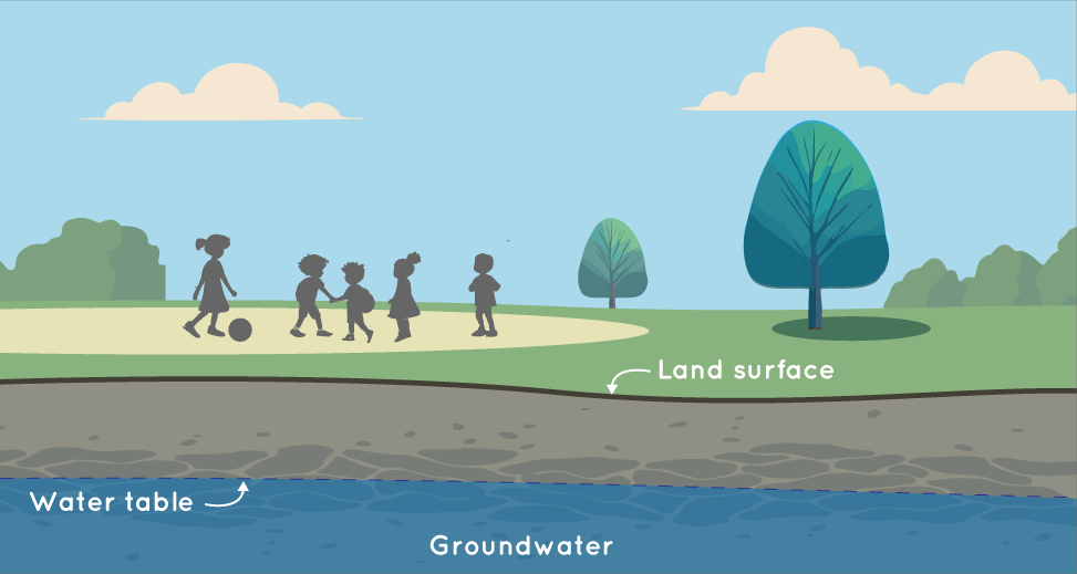
After it rains or snows, water sinks down through the layers of dirt, rocks, and sand in the ground. In certain places, the ground allows enough water to travel through to create a pool of water underground. This is groundwater. The water table is a term for the part of the groundwater that is closest to the surface. Credit: NASA/JPL Caltech
Groundwater is water found below the surface of the land. As part of the water cycle, water falls to Earth's surface when it rains or snows. Then that water is soaked up by the soil. As it sinks through the ground, it fills in spaces between the rocks, dirt, and sand.
In certain places, enough water can seep through that a pool of water forms underground. This is called an aquifer. Aquifers fill up over time from rain and from snow melting at the surface.
To get the groundwater they need, people dig deep holes called wells. The groundwater seeps into the well through the rocks. Then, people pump it to the surface for drinking and other uses.
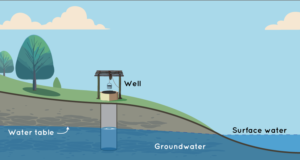
To have water to drink, people sometimes dig deep holes in the ground to reach the groundwater. These are called wells. Credit: NASA/JPL Caltech
Groundwater is a very important natural resource. In the United States, it provides around 40 percent of the water needed for people and farms. For half of the people in the world, aquifers provide the main source of water.
Will Groundwater Change with Climate Change?
Since human-caused climate change raises air temperatures and affects rainfall, it also affects groundwater. Warmer temperatures can lead to people using more groundwater. This leaves less water in the ground. The amount of rain can change the amount of groundwater, too. If there is less rain, then there is less water to refill the groundwater. Warmer temperatures also lead to more evaporation. Evaporation is when liquid water changes into a gas. This means there is less water that can sink down into the ground.
Sea levels are measured around the world with satellites in space and other instruments in the water. Over time, they have shown us that as the planet warms, sea levels are rising. Credit: NASA/JPL Caltech
Rising sea levels also matter. As Earth warms up, it warms the ocean, too. This makes ocean water expand, or take up more space, which causes the ocean to rise. Warmer temperatures also melt land ice in places like Greenland and Antarctica. This adds more water to the ocean and makes it rise.
In some places, rising seas mean that salty ocean water can make its way through the rocks and sand near the coast and into the fresh groundwater. If enough salt water makes it through, then the groundwater may not be drinkable.
Can We Track Groundwater from Space?
Yes, we can! NASA uses satellites to track changes in groundwater from space. For example, the GRACE-FO satellites look at how water moves on and below Earth’s surface by measuring very small changes in gravity.
If there is less groundwater in a place, then it will have slightly less gravity. That’s because how much gravity something has depends on how much of it there is, known as mass. Satellites like GRACE-FO can measure these small changes in gravity when compared to the very large Earth. This gives scientists information about how groundwater is changing over time.
It’s so cool that we can keep an eye on groundwater from space! This means we can help people all over the world know about their local groundwater supply. This information helps them make smart choices about using water.
Related NASA Missions